Materials and method
The coastal zone of Guyana stretches about 430 km, ca. 7% of the total land area of the country. GFC (2011) estimated that the mangroves in Guyana cover an area of ca. 22, 632 ha with region one having the highest coverage of 10,161 ha accounting for approximately 44.90 % (Figure 1 and Figure 2). The study sites were located in the County of Berbice (Regions 5 and 6), the County of Demerara (Regions 3 and 4) and the County of Essequibo (Regions 1 and 2). Five mangrove species are found along most of the coastlines of Guyana with major stands between the Pomeroon and Waini Rivers to the west which represents the largest untouched mangrove forest in the country. These species are Avincennia germinans (L) Stearn, Avicennia schaueriana, Canocarpus erectus, Languncularia racemose (L) Gaertn. and Rizophora mangle (Fanshaw, 1952; Hussein, 1990). This research focused on the biomass carbon of the two most dominant species A. germinans (black mangroves) and R. mangle (red mangroves).
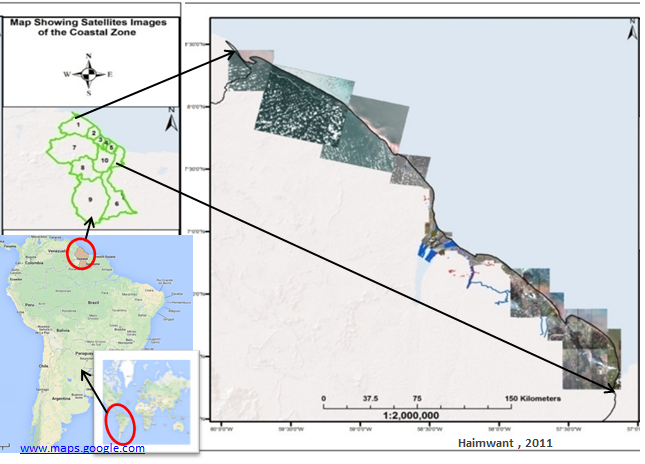
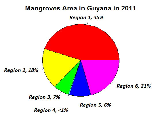
Figure 1: Location of study area Figure 2: Percentage mangrove area in Guyana
Sampling sites are laid out using belt transect method with Random Block Design (RDB). In this study, a belt transects with a length of 140m x 14m running from the inland boundary of the mangroves and going out into the shore was demarcated. This was then further divided into smaller squared plots resulting 10 plots consisting of 14m x 14m each as described in Brown (1997). Random number table was used to select the required three plots along the length of transect. This was done for all the study areas in all the Regions.
Diameter at breast height (DBH) was the principal biophysical measurement. All mangrove trees over 5 cm within the plot were measured and recorded following procedure developed in Pearson et al., (2005). Measurement of DBH is more reliable to deduce allometric equations compared to height measurement (Chave et al., 2005; Brown, 2002). The variables for the estimation of above ground biomass in order of importance and accuracy are DBH (96.9 %), Height (H) (1.2 %) and specific wood density (ρ) (1.1 %). The biomass regression equation developed by Chave et al., (2005) was used to calculate the biomass of the tree.
(ABG)est = ρ * exp[-1.349 + 1.980 ln (D) + 0.207 {ln (D)}^2 – 0.0281 {ln (D)}^3]
Where:
ABG – Aboveground Biomass
ρ – Wood Specific Gravity
exp – Exponential
ln – Natural Logarithm
D – Diameter at Breast Height in meter (1.3 m).
Biomass derived from the equation above was multiplied by area (ha) expansion factor (51.02) to estimate biomass per ha. Biomass was converted to carbon by a carbon factor (0.475).
